
Pipeline Mapping
In the constantly changing realm of utility management and infrastructure maintenance, innovation plays a critical role in securing effectiveness, dependability, and sustainability. Countless towns and cities around the world don’t know exactly what lies beneath, or where it is. This is a problem when installing new infrastructure, assessing the condition of the pipes, and much more. One accurate and unobtrusive method to map pipelines is utilizing a gyroscope and has been used in a variety of domains, spanning electricity, water, gas, and telecommunications – to name a few.

Gyroscopic pipeline mapping, also known as gyroscopic surveying or gyroscopic logging, is a technique used in many industries to accurately map the orientation and trajectory of an item; it could be a pipeline or even a missile! This technology is crucial for ensuring that pipelines are installed correctly and positions accurately recorded. This positional data can be used to provide accurate as-built prints and incorporated into geospatial mapping platforms, such as Google Earth.
With the intricacy of infrastructure, knowing the exact location, orientation, and trajectory of pipelines is the difference between a successful project and an expensive mistake. At American Pipeline Solutions, we can provide you with x, y, z (pitch, roll, and azimuth) within a foot of accuracy, using gyroscopic technology, and we are THE ONLY COMPANY that can do it on a LIVE PIPELINE with a free swimming gyroscope.
Pipeline Mapping Services
In the constantly evolving field of utility management and infrastructure maintenance, pipeline mapping has become essential for ensuring efficiency, dependability, and long-term sustainability. Across the world, countless towns and cities face the challenge of not knowing exactly what lies beneath their streets—or where it is. This uncertainty creates problems when installing new infrastructure, conducting repairs, or assessing the overall condition of existing pipelines.
One of the most accurate and non-intrusive methods of mapping pipeline systems is by using advanced gyroscopic technology. This approach has been successfully applied in many industries, including water, gas, electricity, and telecommunications. At American Pipeline Solutions, we use a cutting-edge pipeline mapping pig to deliver highly accurate results without disrupting live pipelines.
What is Gyroscopic Pipeline Mapping?
Gyroscopic pipeline mapping—sometimes called gyroscopic surveying or gyroscopic logging—is a modern technique used to determine the exact orientation and trajectory of a pipeline. Originally developed for advanced applications such as aerospace and defense, gyroscope technology is now revolutionizing pipeline integrity and infrastructure management.
This method provides precise positional data that can be transformed into accurate as-built drawings and integrated with geospatial mapping platforms such as Google Earth. With the complexity of today’s underground infrastructure, knowing the exact x, y, and z coordinates (pitch, roll, and azimuth) of a pipeline can mean the difference between a successful project and a costly mistake.
At American Pipeline Solutions, we are proud to be the only company able to perform gyroscopic pipeline mapping on a live pipeline using a free-swimming gyroscope—making our pipeline mapping services truly one of a kind.
Why Pipeline Mapping Matters?
Mapping pipeline networks is more than just a technical requirement—it’s a critical safety and planning tool. Without accurate pipeline maps, municipalities, contractors, and utility companies face risks such as:
Accidental strikes when digging or installing new infrastructure
Costly delays due to unknown pipe locations or orientations
Regulatory compliance issues if accurate documentation is missing
Pipeline damage leading to leaks, environmental concerns, or service interruptions
By using gyroscopic pipeline mapping services, operators can eliminate these risks while creating a permanent record of their underground assets.
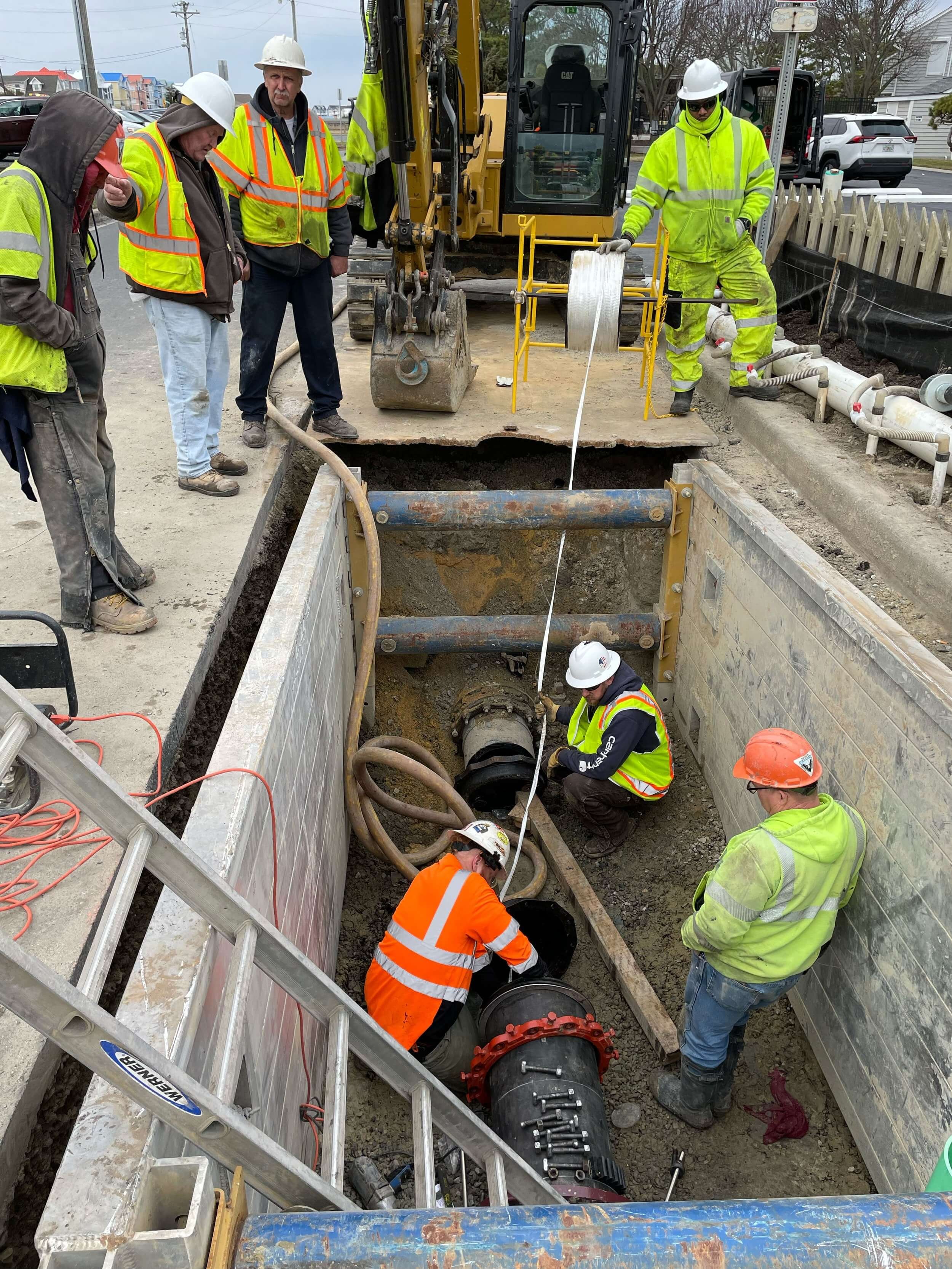
The Process:
Here’s how our pipeline mapping pig and gyroscopic technology work:
Equipment Setup
The heart of the process is the gyroscopic surveying tool, which measures the pipeline’s orientation with extreme precision. These gyro tools are built to withstand the unique conditions inside pipelines.
Deployment
The tool is attached to a logging cable and inserted into the pipeline through a surface access point. For live pipelines, we launch a specially designed gyro pig that travels freely inside the pipe, gathering data along the way.
Data Acquisition
As the tool moves through the pipe, it continuously records orientation data in three dimensions—capturing pitch, roll, and azimuth with remarkable accuracy.
Data Analysis
Once the survey is complete, the data is securely uploaded to the cloud for advanced analysis. Our experts process the information to generate a detailed 2D or 3D model of the pipeline’s trajectory.
Report Generation
We produce a comprehensive report containing depth, diameter changes, and any deviations detected during the survey. This ensures a complete record of the pipeline’s condition and orientation.
Interpretation and Decision-Making
With accurate mapping pipeline data in hand, engineers and operators can make smarter decisions about repairs, maintenance, or reroutes. Issues can be identified before they become costly problems.
Documentation and Compliance
Finally, the data and reports serve as official documentation, supporting compliance with industry regulations and standards. For newly installed pipelines, this is an invaluable record for long-term asset management.
The American Pipeline Solutions Advantage
Not all pipeline mapping services are created equal. At APS, we offer unmatched accuracy and innovation, including:
Live Pipeline Capability – The only company to offer gyroscopic mapping on active pipelines.
Pinpoint Accuracy – Measurements within a foot of accuracy for x, y, z coordinates.
Non-Intrusive Process – No excavation or disruption to your pipeline system.
Comprehensive Reports – Easy-to-understand 2D and 3D pipeline trajectory visualizations.
Versatility – Effective across multiple industries, including oil, gas, water, and telecom.
Industries That Benefit from Pipeline Mapping
Our pipeline mapping pig and gyroscopic technology serve a wide range of industries, including:
Oil & Gas – Mapping long-distance transmission pipelines.
Water Utilities – Identifying buried water mains and service lines.
Telecommunications – Documenting underground conduits and fiber optic pathways.
Municipalities – Managing urban infrastructure with confidence.
Construction & Engineering Firms – Supporting safe excavation and planning.
Contact Us for Pipeline Mapping Services
If you need precise and reliable pipeline mapping services, American Pipeline Solutions is your trusted partner. With our advanced gyroscopic tools and exclusive live pipeline capabilities, we provide the data you need to manage assets, reduce risk, and ensure compliance.
Contact us today to learn more about how our pipeline mapping pig technology can safeguard your next project.
Contact Us today for more information!
FAQs;
What is gyroscopic pipeline mapping?
Gyroscopic pipeline mapping is a technique that uses a gyroscope-based tool to measure the exact orientation and trajectory of a pipeline in three dimensions. As the tool travels through the line, it records pitch, roll, and azimuth. This data is then converted into accurate as-built drawings and 2D/3D models that show where the pipe actually lies underground.
How accurate is gyroscopic pipeline mapping from APS?
American Pipeline Solutions can provide x, y, and z coordinates (pitch, roll, and azimuth) within about a foot of accuracy. That level of precision helps engineers avoid costly mistakes when planning new construction, excavations, tie-ins, or reroutes. It also creates a reliable long-term record for asset management and regulatory documentation.
Can APS perform gyroscopic mapping on live pipelines?
Yes. APS can perform gyroscopic pipeline mapping on live pipelines using a free-swimming gyro pig. This means operators don’t need to excavate or shut down the line to get accurate positional data, significantly reducing disruption, cost, and downtime.
How does a pipeline mapping pig work?
A pipeline mapping pig is equipped with a gyroscopic surveying tool that is launched into the pipeline through an access point. As it moves through the line, it continuously records orientation and trajectory data. After the run, APS uploads and analyzes the data to create detailed 2D and 3D models, plus a comprehensive report on depth, bends, and deviations.
Why is pipeline mapping important for utilities and municipalities?
Accurate pipeline maps help prevent accidental strikes, unexpected delays, and regulatory issues. Municipalities, utilities, and contractors can see exactly where lines are, how deep they run, and how they curve or change direction. This supports safer excavations, better planning, and more efficient maintenance programs across busy urban environments.
What kind of data do I receive from a gyroscopic pipeline survey?
You receive precise x, y, z coordinate data along the pipeline, showing pitch, roll, and azimuth throughout the route. APS converts this into clear 2D or 3D trajectory visualizations, depth profiles, and reports on diameter changes or deviations. This data can be imported into GIS and geospatial platforms such as Google Earth.
How is gyroscopic pipeline mapping different from traditional locating methods?
Traditional locating methods often rely on surface indicators, partial records, or indirect detection, which can be incomplete or inaccurate. Gyroscopic mapping captures the actual in-pipe path, independent of above-ground obstacles or missing records. The result is a precise, continuous profile of the pipeline’s route, even in congested or built-up areas.
Does gyroscopic pipeline mapping require excavation or shutdowns?
No. One of the major advantages of APS’s approach is that the mapping pig travels inside the pipeline, so there’s no need to dig up streets or expose the pipe. For many systems, especially where APS can use a free-swimming gyro pig, mapping can be done on a live line with minimal operational disruption.
Which industries benefit most from gyroscopic pipeline mapping?
Gyroscopic pipeline mapping is valuable for oil and gas, water utilities, telecommunications, municipalities, and engineering firms. Long-distance transmission lines, buried water mains, fiber conduits, and complex urban networks all benefit from accurate, modern mapping. Any operator that needs to know exactly “what’s beneath and where it is” can use this service.


